
Rezoning is back on the table for Lowry Hill East. Here are some maps to help you understand the history of neighborhood zoning and the potential impact of the city's current proposal.
Pre-1975
The zoning map below is from a time (before I-94 separated Lowry Hill East from Loring Park and downtown) when the neighborhood was zoned entirely for high-density housing (R6).

1975: first downzoning
The Lowry Hill East Neighborhood Association's founding mission was to eliminate the zoning that allowed the construction of apartment buildings. They were hugely successful. Our current zoning largely resembles the map below, recommended by LHENA in 1975. Today, 60% of neighborhood properties are zoned low-density (roughly 435 out of 725 parcels zoned R2B).

2004: a push for single family zoning
In 2004, political pressure led the city to enact an apartment building moratorium and conduct a rezoning study. LHENA recommended the zoning map below. The LHENA plan would have eliminated high-density zoning entirely, and designated six blocks in the center of the neighborhood where a majority of properties (69) would be downzoned to single-family (R1A). The homeowners behind this plan were unwilling to compromise with the city, and rezoning was tabled indefinitely.
 |
| Proposed single-family core in red box. |
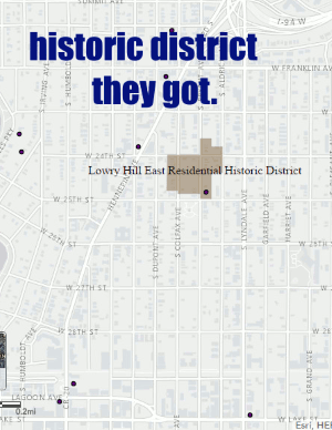
2008-2015: historic district
The desire for a super-expansive historic district was pretty transparently about stopping new apartments. The energy behind creating a historic district just happened to bubble up after the failed attempt at downzoning the neighborhood in 2004. A historic district of modest scope was officially designated by the city in 2015.
2016 downzoning plan offered by the city
The city's current proposal (my reaction here) resembles what was rejected by homeowners in 2004. Most significantly, the plan would eliminate much of the high-density zoning in the transit-rich northern part of the neighborhood.

Lowry Hill East as currently constituted is not allowed by zoning.
The map I have created below shows (1) existing buildings that could not be built today because they have too many dwelling units and (2) additional buildings that would have "too many units" if the city's current rezoning proposal were implemented. The neighborhood as it exists is effectively not allowed by zoning. If you think that's a problem, we're about to make it worse. |
| This map is not comprehensive. There are certainly more nonconformities. |